China in infographics
A Q&A with Peter Wood on his superb series of Chinese military and foreign affairs infographics.
The China Project recently corresponded with Peter Wood, editor of the China Brief at the Jamestown Foundation in Washington, D.C., a widely read source of analysis on China, particularly its military and foreign affairs development.
We asked Peter a few questions about his series of fascinating infographics:
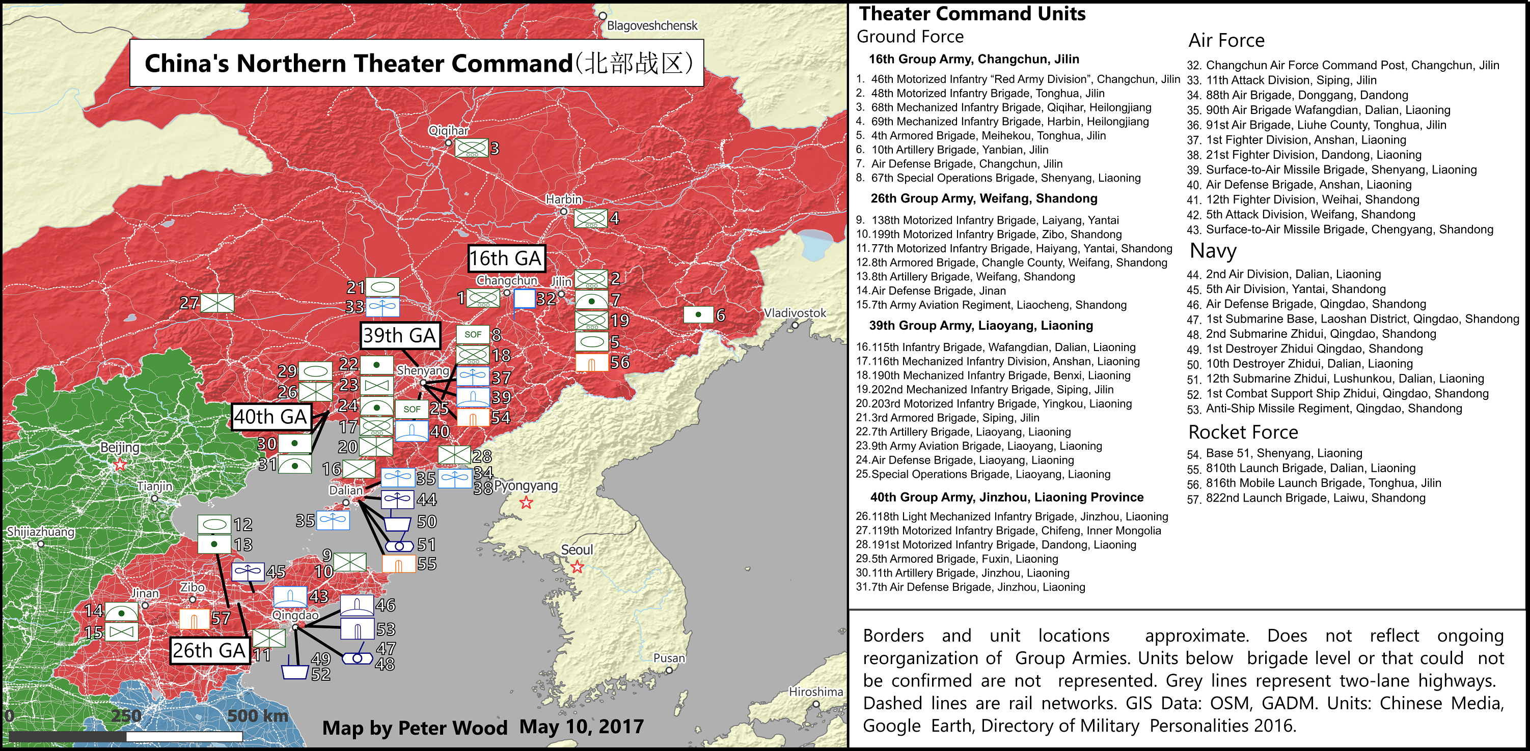
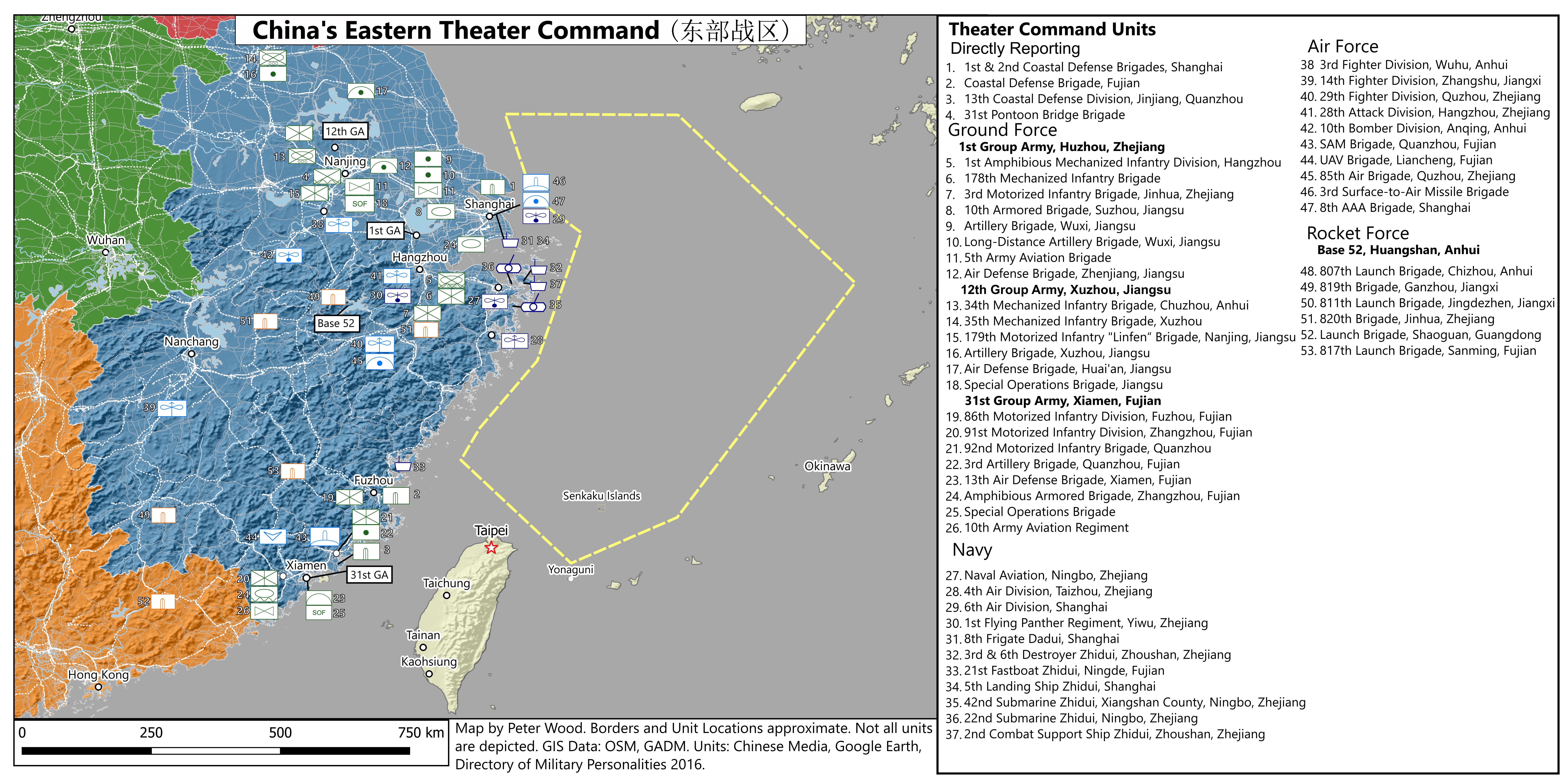
China’s Northern and Eastern Theater Commands
The China Project: Why make these maps?
Peter: China’s a big country, has a large military, and is involved in at least four potential conflict areas with the United States: North Korea, Taiwan, the Senkaku Islands, and the South China Sea. After the December 2015 PLA reforms and creation of the theater commands, I realized there was a need for some kind of “backgrounder” on each of the theaters — geography, their role, and major units — in a way that was easy to understand. (I needed it, too.) Thus far, Kevin McCauley and I have written profiles of four out of the five commands (Eastern, Southern, Western, Northern, and Central). Later this year, I am planning on issuing collected and expanded versions of the articles as a short book.
The China Project: Why is the Eastern Theater Command important?
Peter: East is China’s most important military strategic direction. (I’d argue that internal stability is the highest security priority, but that is a separate issue.) The Eastern Theater Command includes responsibility for Taiwan and conflicts with Japan — and by extension, the most likely area for conflict with the United States. I think it’s important to understand that the Eastern Theater Command is also so important to China economically — there is a population the size of the U.S. within the Eastern Theater Command’s borders! So understanding the basics of the geography and major units there is important to how China views its security environment.
The China Project: Why is the Northern Theater Command important?
Peter: In the 1980s, the answer would have definitely been the border with Russia. Now, North Korea is probably the most important, though units in the Northern Theater Command have responsibility for strikes against Japan during a crisis. I think the concentration of units closer to the border with North Korea is noteworthy. That is partly due to their posture when the Soviets were the biggest threat — active defense — lure the enemy deep. But also to protect important industrial areas in a crisis on the Korean Peninsula. Everyone sees China as a magic bullet to get North Korea to comply with international norms. But China has its own interests to think of, and analysis of its population distribution, economy in the area, and force posture provides some valuable insight there.
The China Project: How did you make these maps?
Peter: The maps are based on a database I have been working on for a couple of years. I started collecting everything I could about Chinese military units in 2013 or so. What started out as a simple text database with English and Chinese names grew to include geolocations as I figured out where stuff was located based on images in Chinese news reports and Google Earth.
Submarines and missiles
Both available here: https://jamestown.org/programs/cb/resources/

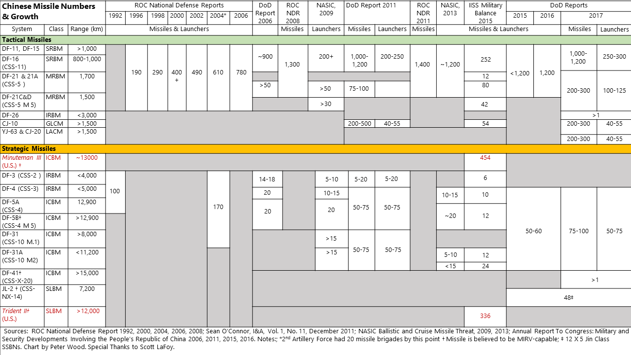
The China Project: Why submarines?
Peter: Earlier in June, Secretary of Defense James Mattis mentioned that Chinese submarines are an emerging threat to the United States. Chinese missile capabilities are a major part of its offensive capabilities — especially against Taiwan. These two charts are meant to provide a baseline for understanding the growth in their numbers and capabilities.
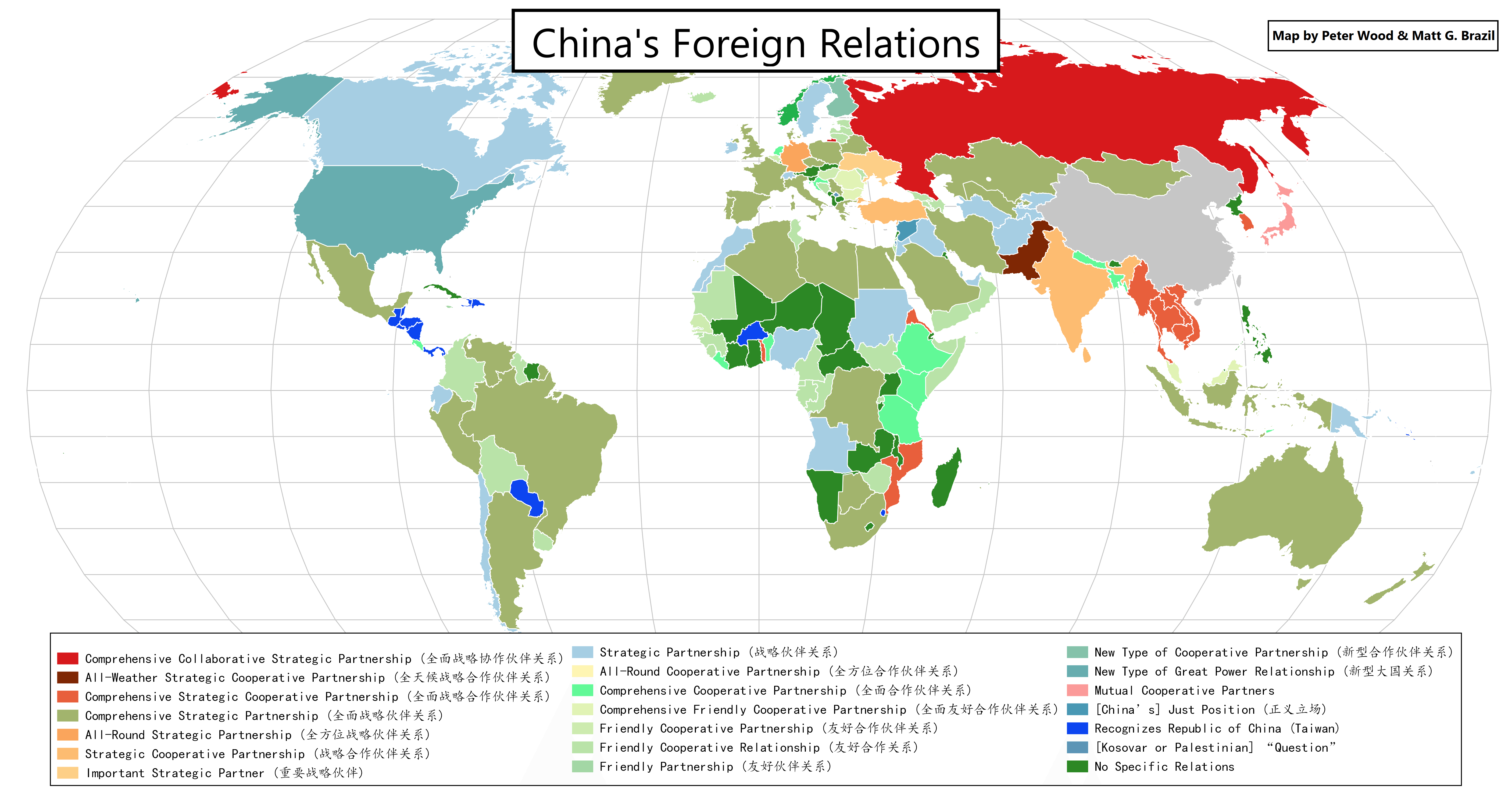
China’s foreign relations
Available here: https://www.p-wood.co/2016/09/18/chinas-foreign-relations/

The China Project: I see lots of different colors — what does this mean?
Peter: China’s foreign relations are incredibly complicated. They have these awkward set phrases that are mentioned every time China’s relations with a country is brought up but are clunky and don’t provide real context. I wanted to see what China’s relations looked like, so my intern and I collected all of them (full credit to my intern who spent hours finding the more obscure ones) and then coded them based on Chinese set phrases such as Comprehensive Friendly Cooperative Partnership. I think seeing the patterns is even more important in context of the Belt and Road Initiative and China’s pushes for influence in ASEAN. We’ve seen a number of changes since the last update. The amount of dark blue — the color for countries that recognize Taiwan, not the PRC — has shrunk since the making of this infographic: Panama and Nauru have switched their diplomatic recognition.
China research source sheet
https://jamestown.org/wp-content/uploads/2017/06/China-Research-Source-Sheet.pdf
The China Project: Why collect all these state, Party, and news websites?
Peter: I think it is really easy to get lulled into just reading the same sources over and over again. Chinese is difficult. More and more state media is being presented in English. But the more interesting stuff tends to not be something the Ministry of Foreign Affairs spokesperson said — its announcements of appointments in obscure bureaus, or editorials by someone you have to look at an organizational chart to find. I wanted to help other China wonks to get off the beaten track and go find interesting stuff, which is why I’ve been expanding China Brief’s Resources page. China produces a truly enormous volume of news, editorials, white papers, and other reports, of which only a tiny fraction will ever be translated. But the laws, appointments, and factional jostling that is apparent in some Chinese reports have big impacts for foreign businesses and foreign policy, so it’s worth trying to understand. China Brief and other Jamestown publications are focused on attempting to address just that issue — taking non-English sources and providing neutral analysis of major geopolitical events and trends.
Population density of China
Available here: https://jamestown.org/program/xi-jinping-china/
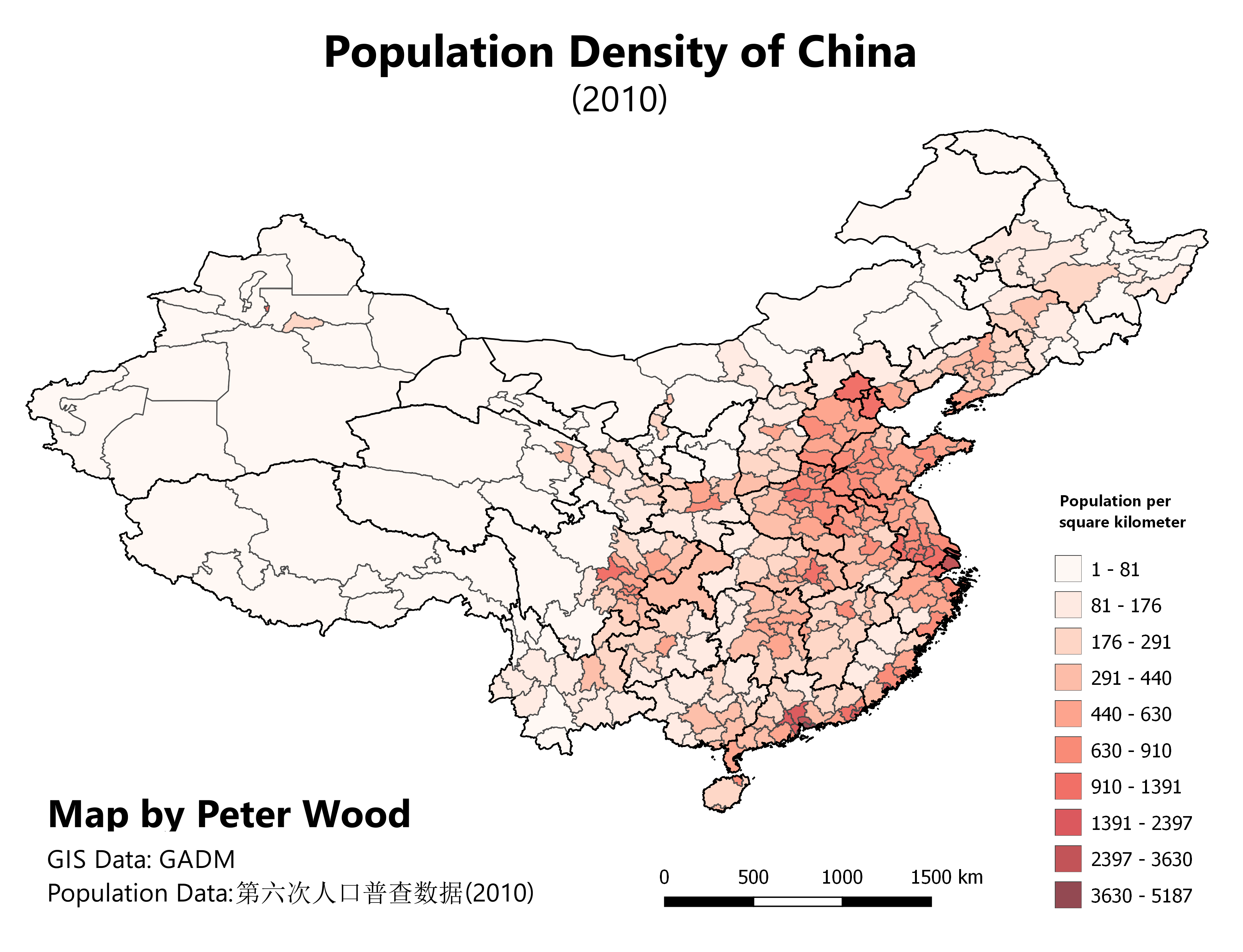
The China Project: Why make a population density map? Aren’t there already so many of those?
Peter: When I started studying China, one of the most powerful insights into how the country was organized came from stumbling across the Heihe-Tongchang line, a notional line between points on two corners of the country that divides the country into two parts, with 6 percent of China’s population to the west and 94 percent to the east. I used data from the 2010 census to build a map of China at the prefectural level, which pretty much tracks with the Heihe-Tongchang line. This highlights how densely clustered China’s population is to the east and along a few nodes in the interior. The east coast has received the majority of the benefits of China’s modernization, while the west has been somewhat left behind.
At the end of the day, the first person I am trying to make these for is myself — to help me understand normative factors beyond politics that affect how China and its neighbors interact: geography, demographics, transportation, food production, and how these influence China’s national interests. I think whether you are a “panda hugger” or a “China hawk,” a loyal CCP cadre or a DPP-independence advocate, I think all of us would do a lot better in managing our differences if we had a more accurate understanding of all parties’ interests. Maps and graphics are one of the simplest and most effective ways to provide that.
Peter Wood is the editor of China Brief. You can follow him on Twitter @PeterWood_PDW.